1999-2010
Showing posts with label tsunami. Show all posts

Tuesday, December 02, 2008

KTLA's Lu Parker covers our tsunami sign story


Our continuing coverage of the TSUNAMI HAZARD ZONE terror signs along the Pacific Coast Highway in Los Angeles reaches a far wider audience tonight as KTLA news reporter Lu Parker is covering the story for the KTLA Prime News broadcast at 10 pm tonight-- and probably the morning show tomorrow.

Emmy-winning Lu, one of the most respected broadcast journalists in Los Angeles, picked up the story from the Tabloid Baby site and interviewed Tabloid Baby's editor for the report, along with the original Tabloid Baby, who first pointed out the frightening postings.

The story was also reported today in the Santa Monica Daily News.


(TABLOID BABY FUN FACT: Lu Parker was the 1994 Miss USA, succeeding 1993 Miss USA Kenya Moore, who starred in Cloud 9, the classic 2006 comedy from our pals at Frozen Pictures.)

Santa Monica newspaper picks up our tsunami sign terror story; finds local disaster unlikely


Our coverage of the sudden proliferation of TSUNAMI HAZARD signs on and around the Pacific Coast Highway in Los Angeles has spread throughout the Los Angeles media and been picked up by several news outlets.

The Santa Monica Daily Press newspaper today takes the reportage in a new direction. In a Page One story, Reporter Melanie Hanatani finds that the signs are part of a "public education campaign" by various city and state agencies, including the city of Santa Monica, although "the likelihood of a disastrous tsunami is highly unlikely because much of the city is protected by the bluffs.

"According to Paul Weinberg, the emergency services coordinator for the SMFD: 'The worst we would expect in the city of Santa Monica is ankle-deep water at Main Street.'"

Santa Monica Daily Press
December 2, 2008


Tsunami warning signs posted along PCH

BY MELODY HANATANI

Daily Press Staff Writer

Burt Kearns was enjoying a walk to Will Rogers State Beach with his two young children recently when an unfamiliar sign put a damper on the trip.

Illustrating a giant wave, the sign informed the trio that they were entering a Tsunami Hazard Zone.

The placement of the sign was perplexing to say the least for the Pacific Palisades resident.

“I was upset my son was suddenly worried to go walking on the beach,” Kearns said.

The Los Angeles Emergency Management Department began posting the signs along Pacific Coast Highway between the Santa Monica and Malibu borders and in Venice last week to warn of the possibilities that a natural disaster could strike. The signs identify tsunami hazard areas and point out evacuation routes.

The signs are part of a public education campaign being undertaken by coastal cities up and down the state to prepare residents for how to survive a tsunami, which is a series of waves usually brought on by an earthquake.

Many had no idea of the dangers posed by tsunamis until the catastrophic 2004 Sumatra Tsunami in Southeast Asia that killed more than 225,000 people.

“Any time an earthquake happens out in the western seas away from us, it could have an impact on us and the coastal communities,” Richard Deppisch,the emergency preparedness coordinator for the city of Los Angeles, said. “I think a lot ofthe public realizes that it could be dangerous if they live close to the water.

“Whether or not it happens in our lifetime, you can’t say.”

The city of Los Angeles and Santa Monica City Hall are among 14 Los Angeles County cities in the Operational Areas Tsunami Task Force, which formed in 1999 after several studies suggested that agencies formulate an emergency preparedness strategy much like they do for earthquakes.

The task force is currently waiting for the Governor’s Office of Emergency Services to complete a new map that identifies the tsunami hazard zones.The map,which is expected to be completed in the first quarter of 2009, will allow the task force and its member cities to identify where warning signs should be posted, according to Jeff Terry, who heads the multiagency group.

The L.A. Emergency Management Department is the only member that decided to move ahead with its sign program, Terry said.

Once the map is completed, the task force will launch a demonstration project in several cities to gauge residents’ response to the signs.

The project is estimated to cost about $250,000. In the event of an emergency,the National Weather Service would send a tsunami warning to Sacramento, which would forward the notice to all local counties, which in turn would contact its coastal cities. Each city would then set into motion its own emergency response plan.

In Santa Monica,that plan would entail collaboration between the Santa Monica Fire and Police departments who would send out a mass notification for all affected residents to evacuate.

The impacted areas in Santa Monica include Palisades Beach Road,which is located north of the Santa Monica Pier, and the neighborhood west of Fourth Street in Ocean Park.

But the likelihood of a disastrous tsunami is highly unlikely because much of the city is protected by the bluffs, according to Paul Weinberg, the emergency services coordinator for the SMFD. “The worst we would expect in the city of Santa Monica is ankle-deep water at Main Street,” he said.

“About 99.9 percent of the city is absolutely protected.”

Weinberg said he expects to see similar evacuation and warning signs posted in Santa Monica. The signs could be covered by federal funds.

The office of L.A. Councilmember Bill Rosendahl contributed about $4,000 for the signs that were posted in Los Angeles.

Rosendahl said he has not heard any complaints from residents about the signs.

“The ocean is right there, it’s in our immediate presence,”he said.“It’s a precaution to do this.”

But some residents have wondered whether the signs are necessary.

Kearns, who runs the blog Tabloidbaby.com, commented about the new signs on his site, upset about the impact their presence would have on visitors.

“What’s next? A shark hazard zone, a fat people in Speedos zone?” Kearns said. “Everyone knows that we live in an earthquake area and that there’s the possibility of a tsunami.

“It seems to be an anti-tourist move.”

Monday, December 01, 2008

Tsunami sign terror campaign is statewide


Our probe of the TSUNAMI HAZARD signs that have shown up along the Pacific Coast Highway in Los Angeles has led to investigations by other news sources. The LAist site has found that the California Department of Transportation is responsible for the signs, and is offering cities and towns along the coast a variety of styles and warnings (above).

And Tabloid Baby has just learned that the signs that appeared on the PCH along Pacific Palisades are set to be posted on beaches in Santa Monica and Venice next week.

In fact, the signs are set to appear along the entire California coastline, and have been posted for about a month in northern California, causing Franklin Stover of The Humboldt Beacon to ask whether the signs are the work of anti-development types and if their placement will drive down property values along the coast:

"... Approximately 400 of these signs were installed by Caltrans with a 5 percent loss due to sign stealing...

"The State of California's Seismic Safety Commission states in their Dec. 2005 'Findings and Recommendations On Tsunami Hazards and Risks' that 'over 80 tsunamis have been observed or recorded along the coast of California in the past 150 years, 9 causing minor damage in ports and harbors and 2 with major impacts.' It goes on to remind us of the Cresecent City tsunami of 1964 that resulted in four deaths. Finally, in that same paragraph, the study says, 'local earthquakes can produce damaging tsunamis that will provide very little warning time.'

"This brings me to ask what value the hazard warning signs have if I'm a motorist on 101 and a big tsunami reaches up and devours me and the road with it. In the time alloted (nearly zero) to respond, there's no way to move to high ground unless one is aided by extraterrestials.

"True to human nature, we've known about the risks of living by the coast for 150 years, but homes, highways, a mall, a community college, and a nuclear power plant dot the landscape along an area marked as a hazardous tsunami zone.

"Another thing that the hazard signs accomplish is that they tend to discourage development of those areas. This may be to the delight of progressives who don't want that kind of progress, but it brings up a question of declining property values. Now that these hazard areas have been carefully delineated, could land there be devalued since the risks of living there or running a business are at odds with Mother Nature? Should it be appraised at a lower level, however, economic opportunities within the tsunami hazard zone could be unleashed. Still, one must bear in mind what nature may have in mind.

Sunday, November 30, 2008

Update: City of Los Angeles named on signs in Pacific Coast Highway tsunami terror campaign


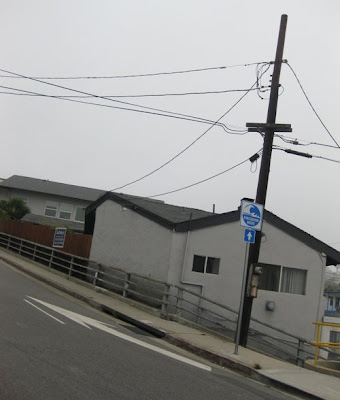
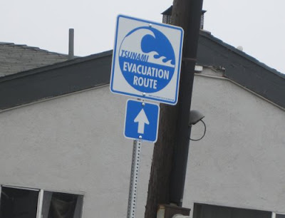
It appears that the tsunami sign terror campaign aimed at Los Angeles beachgoers is being waged by the city of Los Angeles itself. The "TSUNAMI HAZARD ZONE" and "TSUNAMI EVACUATION ROUTE" signs that have appeared on the Pacific Coast Highway and its access road intersections are marked "Property City of Los Angeles."

The signs also bear the name "Maneri." The Maneri Sign Company is located in Gardena (City Hall reporters, do your thing...)


Our favorite so far?


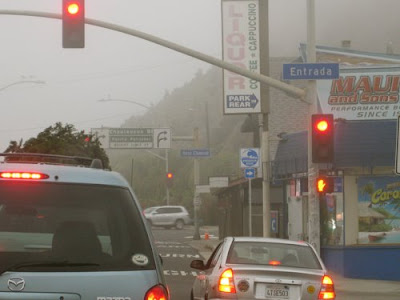
At the three-way intersection of the PCH, West Channel Road and Chautauqua Boulevard, where drivers can leave the PCH and head along the low, flat West Channel into Santa Monica, or take a steep, rising hill up into Pacific Palisades.


Chautauqua Boulevard-- the steep, rising hill-- is marked "TSUNAMI EVACUATION ROUTE," as if one fleeing rising waters would need to be directed to choose the road leading to higher ground.


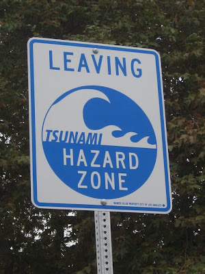
Drivers taking the low, flat West Channel Road route will find a LEAVING TSUNAMI HAZARD ZONE sign a couple of hundred yards down the road. That would be a couple of hundred yards away from the beach and the direction of the approaching waters.

An investigation today revealed that the TSUNAMI EVACUATION ROUTE signs are posted along the Pacific Coast Highway before all major access roads north of the California incline in Santa Monica and south of Malibu (Veronique de Turenne of the Here in Malibu site tells us the signs have not been posted in Malibu).


The appearance of the signs has more than a few people wondering why the government would want to drive tourists and beachgoers away from the vast, wide beaches of Will Rogers State Park. There are suspicions that government officials have some advance warning of an impending earthquake or underwater test that would trigger a tsunami-- a long high sea wave caused by an earthquake, submarine landslide or other disturbance.

A 2004 study by researchers at the University of Southern California showed that a 7.6 magnitude earthquake could cause the seafloor under Catalina Island to be thrust upward violently, causing a tsunami along the Southern California coast.

The researchers at the Viterbi School of Engineering described the tsunami hazard associated with offshore faults, including one that lies under Santa Catalina Island, just 25 miles off the Los Angeles coast.

"Catalina Island itself exists due to earthquake-related uplift on a geologic structure known as a restraining bend," said Mark Legg, a geophysicist working with the USC researchers, in the August 2004 issue of Earthquake Spectra.

"Although most faults offshore Los Angeles and Orange counties are mostly strike-slip-- faults that move side to side-- bends in the fault line produce areas where the ground is pushed up during major earthquakes. One of these regions lies directly below Santa Catalina Island."

"Strike slip faults are not straight," added Jose C. Borrero, assistant research professor in the USC Viterbi School. "Bends in the fault trace produce regions where earthquake stresses cause the sea floor to pop up and generate a tsunami".

A random survey of shoppers at the Gelsons supermarket in Pacific Palisades this afternoon found a majority of respondents reacting in bemused disbelief. Said one: "Fear. More fear."

Saturday, November 29, 2008

'TSUNAMI HAZARD ZONE' signs spoil beach experience along the Pacific Coast Highway


Somebody's found a new way to spoil the Southern California beach experience. One of the kids began pointing it out this week while we were driving up the Pacific Coast Highway from Santa Monica towards Malibu. But we didn't get a good look until yesterday, walking down Temescal Canyon Road in Pacific Palisades toward the PCH, headed to Will Rogers State Beach.

There's a new sign posted at the intersection:

ENTERING
TSUNAMI
HAZARD ZONE

And on the other side of the street, leading up the hill, a companion sign:

LEAVING
TSUNAMI
HAZARD ZONE

TSUNAMI HAZARD ZONE? Now there's a good idea! Not RECREATION ZONE or BEACH VOLLEYBALL ZONE, but something sure to send a chill down the spine. And it was certainly good enough to scare the kids who were old enough to read, filling them with worry and dread as they stood on the wide expanse of beach and looked out toward the ocean.

The signs are at every access road to the PCH from Santa Monica at least to Malibu and most likely farther along than that.

That's a lot of signs, and we've got to figure the expenditure was less likely the work of some politically-correct do-gooder inspired by the Indian Ocean tsunami of 2004 (the natural disaster most Americans wouldn't have blinked at, had not a vacationing Western supermodel lost her boyfriend in the waters) than some politician who took advantage of the publicity and projections to slide this pork expenditure to a campaign-contributing sign company.


The "LEAVING TSUNAMI HAZARD ZONE" is what gives away the game. It's one thing to post reminders for those approaching the beach. But is it really necessary to find an arbitrary point, a few dozen yards from the PCH, to post a sign to assure the hapless beachgoer, running from the approaching tide, that he's safe? Is that really the boundary of the TSUNAMI HAZARD ZONE? What if the person fleeing a tsunami sees the sign, stops running, and is sucked into the surf?

Which leads to other questions: Do government officials know something they're not telling us? Is an earthquake, Pacific Ocean anomaly or ice shelf phenomenon expected to cause a tsunami in the near future? Have the signs been posted to help combat lawsuits from victims and survivors?


No, the real question is why the bureaucrats needed to find another way make people afraid even when they're trying to forget their cares for a couple of hours. Most people headed toward the shores of a great ocean would assume the hazards of big waves, rocks, riptides, sharks, sharp objects in the sand, too much sun, and the sight of fat people on bikinis. That's a lot of signs.

Thanks for ruining it for the kids.